You now know what to do. Or not!
http://m.koreus.com/video/wapiti-vs-photographe.html
Author Archives: Peter
If you meet a deer on the trail.
Posted in Blog
Getting on Base
 When hiking I usually look for items that will handle the environment and be lightweight so that I’m not carrying more than I have to. As you will often experience different temperature changes due to weather and physical exertion one of the most important things you can do to maintain your comfort is to consider base layers. What is a “base layer”? It’s the layer of clothing you wear closest to your skin. It has two main objectives, temperature control and moisture control. You can buy tops or bottoms, although most people buy tops and settle for thicker pants in colder weather.
Base layers can be either wool or synthetic. Some people find wool too itchy and most people will go the synthetic route. However,  recently Merino wool products have made wool a great alternative to synthetics. As mentioned keeping your temperature and moisture under control is what a good base layer does. It will wick away the sweat but still keep you warm. Wearing cotton after sweating a lot is like having a wet towel around your body. It will feel uncomfortable and the moisture in it will cool rapidly if you take a break, which will make you cold and more susceptible to illness. Another advantage to base layers is their ability to block sunlight, and some even have basic insect repellent capabilities.
Expect to pay $20-$50 for a good base layer. They last for years if you wear them underneath you outer clothing. If the temperature is below 60 °F I rarely hike without a base layer.
I will write some more articles on other layers, but if you want more information here’s some good links on layering and base layers
REI – Layering Basics
Posted in Blog
Pine Mountain Trail – Mile 0 – 3
Hiking Distance: 3 miles each way
Difficulty: Easy to Moderate
The Pine Mountain Trail begins at the junction of Hwy 27 and Hwy 190 near FDR State Park in Georgia. The trail is 23 miles long and could be done as an overnight backpacking trip in one weekend or in various section hikes. The trail is blue blazed but there are lots of spur trails from it that make good opportunities to do loop trails so you avoid backtracking or having to shuttle cars.
There is parking opposite the Country Store (a good place for breakfast). The trail starts a few yards up on Hwy 190. The first 1.25 miles of the trail runs fairly flat on the side of the ridge with occasional winter views. It will then cross Hwy 190 and go through a much more forested area, descending down on the other side of the ridge to some abandoned Fish Hatcheries. Near the Fish Hatcheries you can take a spur trail (blazed white). Go past the Dead Pine campsite marker for about .25 mile. If you turn left on the spur trail, after about .1 miles it will connect to another loop trail called Mountain Creek Nature Trail (blazed red). We turned left on this trail and hiked the loop in a clockwise direction. The total loop is about 3.2 miles. The loop will take you around the edge of Lake Delano and a large campsite. On completing the loop and the short spur trail you can get back to the main Pine Mountain Trail. Just before you cross Hwy 190 again there is the option of taking the Chestnut Oak trail that parallels the Pine Mountain Trail on the other side of the ridge. This trail is about 0.75 miles longer and is more strenuous as it does go back down the ridge and has a few switchbacks. It then ascends the ridge again as you approach the parking lot.
The hike described above is a total of about 8.25 miles. It can be shortened by not doing the loop or the Chestnut Oak trail section. You could also just continue on the Pine Mountain trail. It will intersect Hwy 190 at about 3.25 miles and also at 6.3 miles. However you will then have to back track or shuttle cars.
This is a good trail to do in the Fall for the leaves, or Winter or early Spring as the winter views are good.
Maps can be purchased from the Pine Mountain Trail Association or at the FDR State Park Office
Posted in South Georgia Trails, Uncategorized
Table Rock Trail
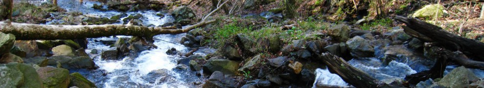
Table Rock trail is one of our annual favorites. It is a 2000 feet climb and a round trip of about 7 miles and is a strenuous hike. However for your effort you get a trail which has a creek, waterfalls, forests, great views and a variety of trail surfaces. There are not many trails that have it all but Table Rock Trail does.
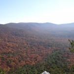
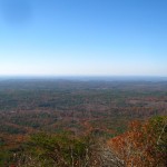
There are about 5 good scenic views as you hike this trail. Each of them will give you a completely different outlook of mountain ranges and plains. When you get to the top of the mountain marked by a large Table Rock sign with the elevation don’t stop there. After about another 1/3 mile you will come to a rock outcrop on the right which gives a tremendous view of the South Carolina Piedmont. A great lunch stop after a serious climb. After this work your way along the trail a little further and around to the other side of the mountain and you will come to another incredible view which displays Table Rock reservoir and the NC mountains.
This hike is best done in the Spring and the Fall. In the summer it will be too hot and humid to make a strenuous climb and in the winter the various rock outcrops could be very slippery.
Table Rock State Park has good facilities for camping and this park is also an access point for the Foothills Trail. The nature center has a great collection of snakes if you are not too squeamish.
More information about Table Rock State Park is available at their website.
Posted in South Carolina Trails
Dukes Creek Falls
Distance: 2.2 miles round trip
Difficuly: Easy
 The trail head is located on 1.3 miles along Richard B. Russell Scenic Highway which can be reached from Alt Hwy 75 near Helen, GA. There are plenty of parking spaces for this popular trail. You might want to consider combining this hike with Raven Cliff Falls which is about a mile further up on the Scenic Highway away from Alt 75.
The trail is very well defined and is a gradual downhill to the falls. There are a number of switchbacks and the beginning part includes some boardwalk and some steps.
At the end of the trail there are some boardwalks and two viewing decks which give great views of the Falls.
Hiking this trail is best done in the Spring and Fall to take advantage of the Spring rains and the Fall colors.
Dukes Creek Falls Trail
loading map - please wait...
Posted in North East Georgia Trails
Raven Cliff Falls Trail
Hiking Distance: 5 miles round trip
Difficulty: Easy/Moderate
 The trail head is located on 2.3 miles along Richard B. Russell Scenic Highway which can be reached from Alt Hwy 75 near Helen, GA. There are plenty of parking spaces for this popular trail. You might want to consider combining this hike with Dukes Creek Falls which is about a mile back on the Scenic Highway toward Alt 75.
Hiking this trail is best done in the Spring and Fall to take advantage of the Spring rains and the Fall colors. However be prepared for it to be busy especially when you reach the final destination of Raven Cliffs. The trail is fairly easy as it mostly runs alongside Dodd Creek. There are several small foot bridges to cross. If you look carefully as you hike this trail there are a number of small waterfalls and with a short detour off the main trail you can get very close to them. At 2.5 miles you will reach Raven Cliffs which again has a waterfall. There is a way to scale the cliffs by making use of the tree roots between the rocks but this is getting harder to do as a lot of people have done this and the roots are deteriorating. At the top of the cliffs is another trail but it eventually dead ends into the brush.
Raven Cliff Falls Trail
loading map - please wait...
Posted in North East Georgia Trails
Pinhoti Trail/Cave Creek Trail Loop
Hiking Distance: About 7.5 miles
Difficulty: Moderate to Strenuous
The trailhead is at a National Forest Parking area about 1/4 mile down the mountain from Cheaha State Park. You will need to turn left when you come out of the state park. The parking area is located on the right with ample parking for 20+ cars.
The trail starts with a pretty  impressive archway and footpath with animal prints. Once into the forest you will soon (within 5 minutes) come to a fork which will let you take the Pinhoti or the Cave Creek Trail.
If you take the right fork up the hill it will lead you to the Pinhoti and the left fork is the Cave Creek Trail. The Pinhoti trail section is more difficult so it might be advisable to do it first while you have fresh legs. If you take the Pinhoti Trail after another few minutes you will come to another fork in the trail. Turn left on the trail. If you continue straight on the trail it will parallel the road and lead you towards Cheaha State Park.
The Pinhoti trail is a very long trail and this is just a small section of it. This section is quite rugged and you will be walking on rocks for a good part of it. You will also come across sections where you will need three points of contact. There are some great views of the valley of the Talledega National Forest.
The trail will parallel the ridge and get closer and closer to the top of it. It will double back on itself a couple of times. At the first double back point (about 3 miles) you can walk an extra 0.25 miles to an overlook. If you look carefully on the trail you will see a crashed airplane.
Once on the regular trail the Pinhoti will double back again and follow another ridge. After a total of about 4 miles you will see a sign for the Cave Creek Trail. The trail will be a climb up over the ridge between a lot of boulders. Once you hit the ridge top follow the trail for a couple of minutes and on the other side of it you will hopefully see a red blaze for the Cave Creek trail. Don’t be fooled by the direction of the trail. It heads south for just about 200 yards before it doubles back north and it will eventually lead you back to the parking lot after about 3 miles. The trail is mostly wooded without much elevation change and is mostly downhill. You know you are getting close when you cross the place where the trees are clear cut for the power lines.
A pretty good day hike in my opionion.
Cave Creek/Pinhoti Trail
loading map - please wait...
Posted in Alabama Trails
Cheaha State Park – Rock Gardens Trail
 The trailhead is located near cabins 7-10. This trail is only 0.5 mile long but has a descent down part of Cheaha Mountain. It leads to a great overlook of the Talledega National Forest and you can also see Lake Cheaha. The rock ledge provides a great place to have sit and enjoy some lunch.
Posted in Alabama Trails
Cheaha State Park – Pulpit Rock Trail
 The trail is only 0.5 miles but it is a fairly steep descent down Cheaha Mountain. It leads to a great scenic overlook of the Talledega National Forest. If you want to preach from the rock you will need to climb down from the trail and then through a gap and back up to the rock. It’s worth it if heights don’t bother you too much and you are careful.
The trail starts near cabins 1-4.
Posted in Alabama Trails